September 20, 2012
A visit to the farmer’s market and The Wife inspects the breastworks
Sunday morning Labor Day Weekend The Wife and I took our boats to the Waterford Farmer’s Market. Around the Capital District there are farmer’s markets everywhere you look, which I think is a very good thing for farmers and consumers. Some, like the Troy Farmer’s Market is a weekly festival that takes over part of downtown Troy on Saturday mornings and goes indoors in the winter. Others like the Delaware Avenue Farmer’s Market in Albany is hidden in a back parking lot behind the library and held on Tuesday afternoons but only in warm weather.
This farmer’s market is held in a locally unique setting. The vendors are arrayed along the Hudson riverfront some twenty or thirty feet from boats parked along what is called the Canal Harbor. This is a working marine facility. The monumental Visitor’s Center, looming over the harbor with a giant clock facing the water, contains support services for the boats such as showers and ice. Most importantly the dockside provides electricity, water and a pump out station for the head, but no fueling facility.
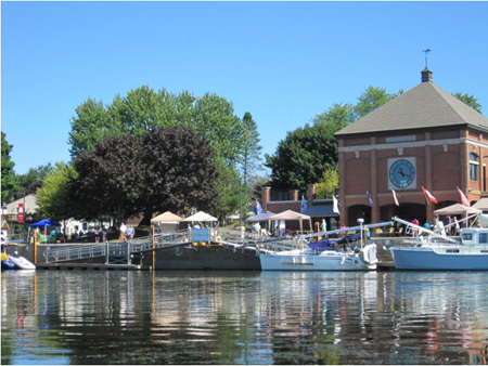 Waterford Canal Harbor, Tents For The Farmer’s Market
And no, we did not paddle my kayak and her canoe twelve miles upriver from Albany. We loaded the boats on top of the terrestrial gas eater and headed for a boat launch in Lansingburg, which is the name of northern Troy. There are lots of obscure boat launches along the upper Hudson, if you want to use one you have to figure out where they are.
This particular launch is along Route 4 and we always have a time remembering where it is. We know the launch sits just south of a Price Chopper, probably the only local supermarket that has docking facilities for marine customers. If we see the store we know we just passed the turn off for the launch. But to our consternation, when we pulled up to the boat launch we saw this:
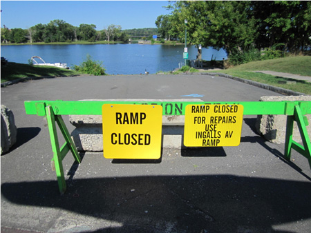 Lansingburg Launch Is No Good, September 2012
Aw come on, what the freakin’ frack is this. It turned out that several concrete paving panels at the water’s edge had slid out of place, this made it a very bad idea to launch a power boat off of a trailer. This is no doubt a delayed consequence of flooding by the two hurricanes Irene and Andrew exactly one year ago. We’ve been seeing this sort of delayed damage to several other boat launches along the Hudson and Mohawk Rivers.
Frustrated, I asked a passing neighbor carrying a shopping bag where Ingalls Avenue is. She had no idea, but she told us people park and carry in their paddle boats all the time. Another neighbor passing by assured us that we were not going to be arrested for disobeying a sign. So we carried in our boats and cast off.
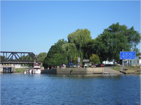 Paddling The Short Distance To The Waterford Boat Launch, At Left Of The Blue Sign
*Update* A regular reader sends this photo of the landing and the blue sign from ten years ago.
In a few minutes we landed on the Waterford side and left our boats to check out the farmer’s market. There’s not a large number of vendors at this one, but the quality of their products is high. As usual they had a musician playing classic songs accompanied by guitar, later after we cast off again we could her her voice singing over the water.
The dockside was lined with parked boats, I didn’t notice any empty berths. At the end of the Canal Harbor basin are the doors of Erie Canal Lock #2 which we didn’t see open the entire time we were there. And we didn’t see much evidence of marine commercial activity that morning, the few water craft we saw were pleasure craft. Of course, this was Sunday morning.
 End Of The Waterford Canal Basin With The Doors Of Erie Canal Lock #2 (Under The Bridge)
The next weekend, after this Labor Day weekend, the basin was going to be the site for the popular annual Tug Boat Roundup which was cancelled last year due to flooding by the two end of summer hurricanes. Large crowds show up for the festivities and to tour the tugboats, the farmer’s market does its best business then. But I do wonder what happens to the boats berthed here, where do they move to for the weekend and when are they allowed to return?
I picked up some very tasty bread and The Wife got a big bag of mushrooms and sweet rolls. I stashed our loot in the hold of my kayak with some frozen water bottles. We used the facilities at the Visitor’s Center and cast off again.
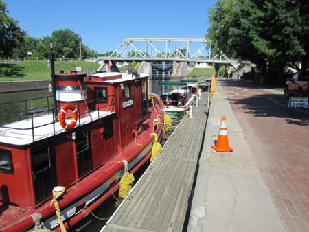
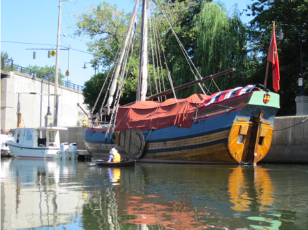 The Onrust Sitting Idle
We pulled up to this wooden sailing ship and said, well what could this be? The owner of the vessel tied up next to it set us straight. It turned out to be the Onrust, a replica of a ship that was built in 1614 somewhere near New York City. It took some 250 skilled volunteers led by a master shipbuilder from Holland about three years to build, finishing in 2009.
The Onrust is very cool, even though it isn’t “the first ocean going ship built in English speaking America” as originally advertised. In fact it was gorgeous, but it looked like it had been tied up to the dock for a while, perhaps months. Now why would this beautiful thing be mothballed on a sunny Labor Day weekend? (Ironically, “Onrust” means “restless” in Dutch.)
Reading some Daily Gazette stories, it appears that a fellow named Don Rittner, who was in charge of publicity and fundraising for the project, has been embroiled in a fight with most of the skilled volunteers who built the boat. The dispute appears to have gotten ugly, but at late summer Rittner appears to have taken control of the actual boat for himself. Unfortunately, the dispute also appears to have driven away potential sponsors for maintaining the ship, sponsors who early on were lining up to be associated with the project.
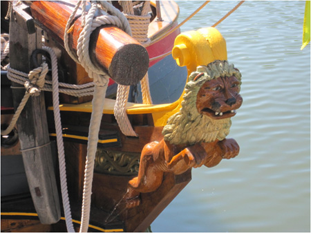 Figurehead At The Prow Of The Onrust. Note The Cobwebs At The Feet.
A wooden ship needs a lot of maintenance, for example the Clearwater is drydocked by its volunteers every year for repairs. Because of the dispute the Onrust now has no money and no skilled volunteers to attend to it’s needs, and here it sits idle during high summer. The vessel has not been Coastguard certified as is required, nor has it been developed into a “floating classroom” as promised.
Now it seems that no municipality wants to give the wooden ship a permanent home, probably because no one wants to inherit the dispute. Looking it over from the dock, I imagined returning to this site a few years from now and seeing the Onrust still sitting there under a blue tarp, decay eating the fancy woodwork and with rot along the waterline. It would be a shame and a crime to see this beauty fall apart from neglect for no particular reason except foolishness.
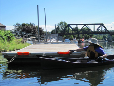 The Wife Inspects The Handicapped Boat Launch
We didn’t want to sit here all day looking at boats so we went out to paddle around. But first we had to go check out the Handicapped Boat Launch that had been installed early in the season. The installation of this unusual dock was the subject of feel-good filler stories in the local media, we were thinking of trying it out for ourselves to see how it worked.
It didn’t look like it was being used very much, I mean, how many paraplegic kayakers are there anyway. We were puzzled and rather alarmed at how high it sat out of the water, anyone going off the end was going to to splash hard. I suppose a person would have to ask someone in charge to get it lowered before using it, which I’m sure is a hassle. I invited the Wife to try it out but she wasn’t in a flying mood.
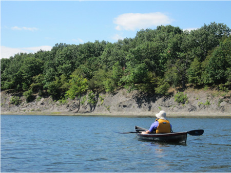
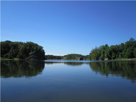 The Now Peaceful Waters Seen From Waterford
It’s hard to remember that within living memory this mostly quiet confluence of waterways was one of the busiest intermodal transportation centers in the country. Geographically, this is where the Mohawk River meets the Hudson River at a right angle, it is also where Lock 5 of the Champlain Canal connects to Lake Champlain. Starting from here a watercraft can travel all the way west to Minnesota or north to Montreal.
In the 1800s and in the early 1900s these waters churned as long lines of commercial boats and barges lined up to enter the locks. Every bit of waterfront in all directions was used for parking boats and the real estate behind the waterfront was nearly priceless. Gangs of working men loaded and unloaded ships throughout the day and night.
 The Wife Contemplates Once Valuable Highway Commercial Real Estate
For more than a century this waterway was actually too small for the traffic it handled, this confluence was a bottleneck on the water highway. After the commercial demands of World War Two in the middle of the 20th Century, most inland boat and barge traffic was replaced by more expensive but more flexible truck transport. The industrial waterway went through decades of neglect and by the turn of the century much of the once valuable surrounding land had reverted back to woodland.
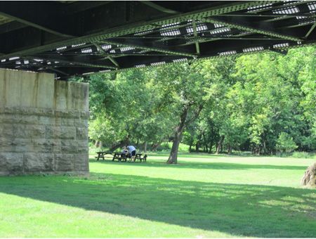 Part Of The Big Picnic Area On Peebles Island
On the other side of the basin is Peebles Island, named for a guy who bought the entire island around 1840 and became very wealthy renting to tenants and storing goods waiting for shipment. Around 1870 a prominent iron railroad bridge called the North Bridge was built which connects Waterford to the island. The current bridge was built after the original was destroyed during the great flood year of 1913.
Today the former railroad bridge has been converted to a walkway and a single lane driveway side by side. After old Mr. Peebles died the island became heavily industrialized. Notably the Peabody Cluett shirt bleaching factory was built starting in 1909 and operated until the 1970s, when it was closed because the rambling facility was considered outdated and too small. Today Peebles Island is a State park.
We of course turned our noses up at the convenient bridge for the tourists, we preferred to paddle across the water like rough pioneers in the wilderness. There’s no real open water around this river junction, every destination requires no strenuous paddling to reach. We ditched our boats at the base of the bridge and walked around part of the island.
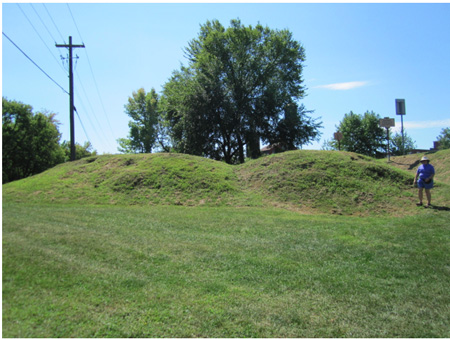 The Breastworks On Peebles Island
In 1777, long before the island was industrialized, a Revolutionary Army detachment under Tadeusz Kosciusko (“Thaddeus” on the historical marker) occupied the island to defend against British General Burgoyne’s expected attack against Albany to the south. Burgoyne never made it this far, his army was stopped at Bemis Heights (usually called the Battle of Saratoga) to the north. Looking around the site and at a map, I decided it was a good thing for our side that the English army didn’t make it to this last line of defense before Albany.
Colonel Kosciusko’s men built an earth rampart across the island to protect the defenders, which a historical marker calls breastworks. Most of the rampart has been leveled over the centuries, but it turns out that a small section survived intact, two mounds. The entire island was once used entirely for industrial purposes, storage and dumping, that sort of thing, so I’m guessing these two mounds survived under a slag or garbage heap and were discovered when the land was cleared of waste and made into a park.
The Wife was delighted by the mounds. “I can see why they call them breast works,” she said. I had to explain to her that the mounds protected men’s lives and the, um, cleavage was probably where they placed the cannon. She climbed one of the mounds and pointed to a woodchuck hole near the top. “Oh look,” she said happily, “the breast works had a lumpectomy.”
 Woodchuck On A Nearby Island, Note The Rough Gravel
Eventually we got back into our boats and shoved off. We went around Peebles Island, or we went as far as we could go before running into dams. Like the rest of the State canal system, the mechanisms of this water highway intersection are a collection of aging but reliable industrial works, all designed to keep boats and barges afloat without the boats being forced to leave the water to cross rapids.
Like I said, at one time every bit of land around here was used. In the water surrounding Peebles there are a number of mostly low, flat islands that are covered with rough gravel and remind me of parking lots. Each of these islands, no matter how small or prone to flooding, has a name. On this trip it occurred to me that these islands must have been altered to accommodate temporary storage of goods waiting for transport. So these islands probably really are former parking lots.
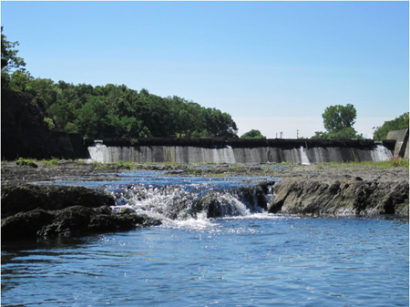 The Dam Behind Peebles Island
One can see the old evidence of intense commercial activity scattered about the waterways, this is usual along the New York State Canal system. The general rule of thumb is that stonework predates the early 1930s, concrete dates afterward. Some of the stonework along the canal system dates back to the 1700s and is still intact, although I don’t think any of the stoneworks in these particular waters goes back before the mid 1800s.
For decades the State let the commercial traffic decline on the canal system, only doing necessary upgrades and maintenance. In the 1990s the State decided to turn the water highway into a playground for pleasure craft and let the commercial traffic fend for itself. Judging by the nearly complete absence of active pleasure boats in these waters on a sunny Labor Day weekend I would say that policy has failed.
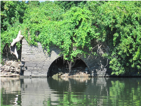 Unused Stone Culvert
One of the reasons the State did not promote commercial activity here around Waterford is that they would have had to dredge the entrance to the Champlain Canal to accommodate large barges. But for decades the State refused to dredge because the operation would have exposed the General Electric PCBs buried in the mud. As a result for the last 40 years or so commercial boats were cut off from Canada and thus we locals were deprived of the economic benefits.
This was done to accommodate General Electric, which didn’t want to clean up their PCBs. Thus we see once again how corporate socialism stifles real economic activity. Fortunately public opinion forced General Electric to start taking responsibility for their merde. And I hear that serious plans are finally being implemented to dredge the Champlain Canal for large commercial boats. Finally!
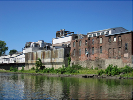 Industrial Buildings Along The Waterford Waterfront
On the far end of Waterford away from the Canal Basin there are indeed working industrial buildings, at least one of which is very noisy. From our vantage point we could see that the older of these buildings once upon a time used the river, that is why they are perched so close to the water. Now the occupants of the buildings ignore the river and the edifices presented to us their ugly backsides.
The water along here is very shallow, especially so this dry year. But I was fascinated to observe a straight boat channel near the shore that was obviously dredged at some point. If someone occupying these buildings wants to start using the river, well, they won’t be pioneers. With a little upgrading everything is ready for commerce.
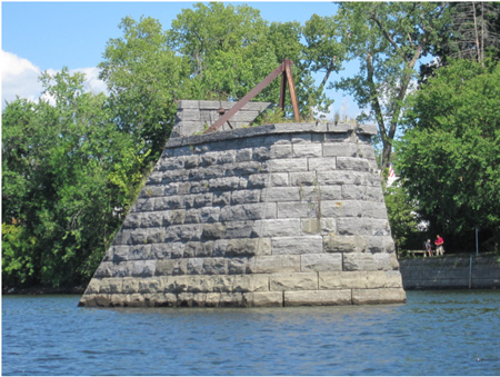 Mysterious Pier Near The Lansingburg Side, What Exactly Was It?
I keep talking about how the State canal system can be used for commerce once again, but we sure like the current peacefulness of the waters. Sure, that’s why we come here on a Sunday morning, to enjoy nature. But as nice as it is that’s not right. This fabulous water highway needs to be used. It’s the reason why Waterford and Albany exist, without the waterway our communities are just dots on the map.
We paddled around the other side of Peebles Island but The Wife, who is a wimp, was getting tired. We’d only been out for about three hours but I could see all this light physical activity was starting to catch up to the serial desk sitter. I figured we’d better end this trip before she started getting crabby so we headed in. As for the farmer’s market loot that we had stashed in the hold of my kayak, it survived just fine.
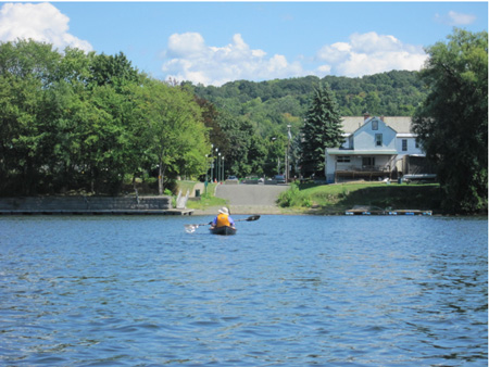 Heading Back To Lansingburg
Prior Post * * * Next Post
Comments:
If you are having difficulties posting a comment, please email Daniel Van Riper. We are experimenting with our spam filters, and we do not want to exclude any legitimate commenters, just spammers!
Posted by:
Posted on:
Comments: